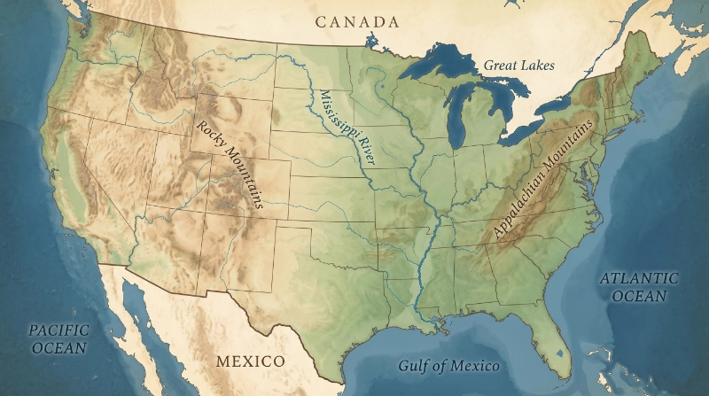
The U.S. citizenship test includes geography questions about America's rivers, oceans, borders, and territories. Key answers include the Mississippi River and Missouri River (longest U.S. rivers), the Pacific Ocean (West Coast) and Atlantic Ocean (East Coast), and the borders with Canada (north) and Mexico (south).
Must-know geography facts:
- Two longest rivers: Mississippi River and Missouri River
- East Coast ocean: Atlantic Ocean
- West Coast ocean: Pacific Ocean
- Northern border: Canada
- Southern border: Mexico
- Capital of the U.S.: Washington, D.C.
- U.S. territories: Puerto Rico, U.S. Virgin Islands, American Samoa, Guam, Northern Mariana Islands
Oceans
The United States is bordered by two oceans:
- Atlantic Ocean — on the East Coast (New York, Florida, Massachusetts)
- Pacific Ocean — on the West Coast (California, Oregon, Washington)
Test question: "What ocean is on the East Coast?" → Atlantic Ocean Test question: "What ocean is on the West Coast?" → Pacific Ocean
Major Rivers
The citizenship test asks you to name one of the two longest rivers:
- Mississippi River — flows from Minnesota to the Gulf of Mexico. It is the most important river in U.S. history — a major trade route and the boundary between many states.
- Missouri River — the longest river in North America. It flows from Montana to where it joins the Mississippi near St. Louis, Missouri.
Other notable rivers (not typically tested but good to know):
- Colorado River — carved the Grand Canyon
- Rio Grande — forms part of the U.S.-Mexico border
Borders
The United States shares borders with two countries:
- Canada — to the north. The U.S.-Canada border is the longest international border in the world (5,525 miles).
- Mexico — to the south. The border runs approximately 1,954 miles from the Pacific Ocean to the Gulf of Mexico.
Test question: "What country is to the north of the United States?" → Canada Test question: "What country is to the south of the United States?" → Mexico
U.S. Territories
The United States has several territories that are not states:
- Puerto Rico — Caribbean island, largest U.S. territory (~3.2 million people)
- U.S. Virgin Islands — Caribbean islands
- American Samoa — South Pacific
- Northern Mariana Islands — Western Pacific
- Guam — Western Pacific
The test may ask: "Name one U.S. territory." Any of the above is correct.
People born in most U.S. territories are U.S. citizens at birth (except American Samoa, where they are U.S. nationals).
The Capital
- The capital of the United States is Washington, D.C.
- D.C. stands for District of Columbia
- It is not part of any state — it is a federal district
- The White House and Capitol Building are located there
States
There are 50 states in the United States. The flag has 50 stars — one for each state. The 13 stripes represent the original 13 colonies.
You should know:
- Your state's capital
- Your state's governor
- Your U.S. Senators (2 per state)
- Your U.S. Representative (based on your district)
These are personalized questions — the answers depend on where you live.
Geography Games on MyCitizenPrep
If you want to reinforce your geography knowledge, try the Name This Place game. It tests your knowledge of famous American locations, landmarks, rivers, and borders — the same topics covered on the test.
The States & Capitals study section also covers all 50 state capitals, organized by region so you can learn them in manageable groups.
Test Questions About Geography
Q: What ocean is on the West Coast of the United States? A: Pacific Ocean
Q: What ocean is on the East Coast of the United States? A: Atlantic Ocean
Q: Name one of the two longest rivers in the United States. A: Mississippi River / Missouri River
Q: What country is to the north of the United States? A: Canada
Q: What country is to the south of the United States? A: Mexico
Q: Name one U.S. territory. A: Puerto Rico / U.S. Virgin Islands / American Samoa / Northern Mariana Islands / Guam
Q: What is the capital of the United States? A: Washington, D.C.
Q: Why does the flag have 50 stars? A: Because there are 50 states
Frequently Asked Questions
What ocean is on the East Coast of the United States?
The Atlantic Ocean is on the East Coast of the United States. It separates the U.S. from Europe and Africa.
What ocean is on the West Coast of the United States?
The Pacific Ocean is on the West Coast of the United States. It is the largest ocean on Earth and separates the U.S. from Asia and Australia.
What are two of the longest rivers in the United States?
The Mississippi River and the Missouri River are the two longest rivers in the United States. They join in St. Louis, Missouri, and flow into the Gulf of Mexico.
What country is on the northern border of the United States?
Canada is on the northern border of the United States. The border is the longest international border in the world, stretching about 5,525 miles.
What country is on the southern border of the United States?
Mexico is on the southern border of the United States. The border runs about 1,954 miles from California to Texas.
What is the capital of the United States?
The capital of the United States is Washington, D.C. (District of Columbia). It is not part of any state — it is a federal district.
Key Takeaways
- Atlantic Ocean = East Coast; Pacific Ocean = West Coast
- Longest rivers: Mississippi and Missouri
- North border: Canada; South border: Mexico
- Capital: Washington, D.C.
- 50 states = 50 stars on the flag; 13 stripes = 13 original colonies
- 5 main territories: Puerto Rico, U.S. Virgin Islands, American Samoa, Northern Mariana Islands, Guam
- Know your state's capital, governor, and representatives